Pictures of this portion of our trip are on Shutterfly at: http://jackbarbic.shutterfly.com/4706
We had another opportunity to see the Teton Mountain Range as we continued north on Rt.26 towards Yellowstone. The Rt.26 heads north until it intersects with the road that leads to both Teton National Park and Yellowstone. It then turns toward the south east. As we went along, nearing the Togowotee Pass (el. 9658 ft.) with 6% grades, we were behind a “side dump” truck. It’s about the length of a semi, the “trailer” is semi-circular, open on top and rotates to dump it’s contents. The truck was loaded and chugging up the pass at no more than 20 mph. Being a narrow two lane road there was no way I would be able to pass so I slowed and ended up with the motor home in low gear. I was pleased at how well it did. Anyway, even if I could have passed it’s a good thing I didn’t. Traffic was stopped near the summit due to road construction. The flag man waved the trunk around the line of stopped cars, turns out the truck was hauling gravel for the road. After sitting a while, I took the opportunity to get out of the motor home just as some irate woman walked by wanting to know “What’s going on” and “How long are we going to be here”. I suggested she talk to the flag man. Times like this is when a motor home is wonderful. We have running water, we have food in the fridge, we can generate electricity to power the microwave (Jackie made us a sandwich while we were waiting) AND WE HAVE A BATHROOM.
After a while a pilot car (truck) showed up and it was time to go. The construction spanned a few miles but at least it was not muddy and messy like the construction we went through in Montana and the detour we took in Nebraska due to the washed out bridge. Unfortunately the paper plat e, the sandwiches now eaten, was on the dash and the reflection shows up in the pictures of the construction.

One thing I’ve noticed on this trip is that there are many places I see that are not the same as but are very similar to places/parks that I’ve been to. The photos below remind me of Brice Canyon and the red rocks in vicinity of Sedona AR.

Later in the day we arrived at Twin Pines campground in Lander WY.
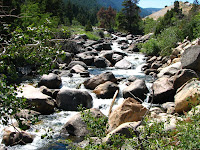
The following day we went to Sinks Canyon State Park. The name come from the river, which flows through the canyon and at about the half way point turns into a limestone cavern and sinks into the ground, known as “The Sink“. It emerges about a quarter mile away, known as “The Rise“.
At “The Rise” is a pool that is loaded with large brown and rainbow trout. They are almost like pets. The state has installed vending machines that visitors can feed the trout pellets of fish food. Considering their size I would suspect many visitors have fed them well. As you might expect, no fishing is allowed. It would be like catching and eating your pet goldfish.
The river has a unique name, Popo Agie. The pronunciation is Po-Po-shuh although a recording and some locals pronounced it Pop-a-shuh.
We are now in Superior CO visiting our son, daughter-in-law and grandchildren. Since we plan to be here until a day or two after l Labor Day, I have put the motor home in a self storage lot in Boulder.
When we leave, we will most likely take I-70 & I-64 eastward with the intention of stopping in Ashland KY for several days. Jackie was doing some digging into her ancestors and discovered that her mother’s step sister had children that are our age, Jackie discovered them, by accident, on ancestry.com when she and her newly found cousin were researching their grandfather. From there it will be time to head south and home.
Jack


No comments:
Post a Comment