Blog Archive

Tuesday, June 22, 2010

Chimney Rock, Scotts Bluff AND Carhenge

Chimney Rock, Scotts Bluff AND Carhenge.

We were camped at the Sunset Motel & RV Park for three days. One of the days we were in Alliance was spent taking a day trip to Chimney Rock And Scott’s Bluff.


These pictures can be accessed at: http://picasaweb.google.com/jackbarbic/19ChimneyRockScottSBluffRS#

Chimney Rock is located along Rt. 92, southwest of Alliance NE. It is 300 feet high and was a landmark used by the pioneers as they went west following the Oregon Trail. Depending on which claim you want to believe, the pioneers first saw Chimney rock when they were two to four travel days away. Since the wagon trains traveled at walking speed and covered about 15 miles a day, Chimney Rock was visible from 30 to 60 miles away.

I thought that the Rattlesnake warning was a clever way to keep visitors from wandering on the plant life.

Chimney Rock is an impressive work of nature in terms of how erosion shaped it. However, you might wonder why it was significant to the pioneers. The explanation we read was that after the pioneers left a jumping off point, like St. Joseph MO the pioneers entered the prairies and plains where the topography was mostly flat, with shallow, rolling hills. It was mile after mile of a land that did not have the hills & trees, the things that the people were used to seeing. So, there was great joy and relief when they saw Chimney Rock for it meant that the trek across the plains was over. Ahead were the mountains, not that they didn’t present problems but at least the plains were behind them.

The Visitors Center is packed with information about the pioneers, the clothes they wore, their tools, the Indians. Snippets for information and a time line from 1812 to modern times. Surprising to me was that dogs did not survive well on the trip and that the oxen were the preferred animal to pull the wagons.


From Chimney Rock we continue northwest on Rt. 92 toward Scott’s Bluff. The day was windy. There was a steady wind of about 20 - 25 mph with gusts to 35 mph. The result was areas where there were “dust storms” with the visibility getting quite low at times. We imagined what it must have been like during the “Dust Bowl” days.


Soon Scotts Bluff came into view. There is the town of Scott’s Bluff and then there is Scotts Bluff National Monument. Being a senior and having one of those geezer National Parks and Federal Recreational Lands Pass, all it took was showing the pass & ID and in we went. The person staffing the gate told us that a road that went to the summit was open so up we went.


What a great view from the top. There are paths, one that would be called strenuous ( I like the “Short, Easy ones) and tidbits of information. The wind driven dust could easily seen in many places.
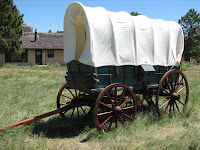
 There was a plaque explaining how Scotts Bluff got it's name, along with a lesson about “companions. There is a gage device that measures the erosion of the bluff. The Visitors Center had great display and a video about the area that was well worth seeing. Outside the center there were wagons, tool etc that the pioneers used. As we returned to Alliance, there was a truck that was hauling a very large tank. I couldn’t resist a picture and the feeling that I was glad I didn’t meet him on some two-lane road.

The following day we went to Carhenge, guarded by strange beasts(where the mysteries of time & space may someday be explained). See pictures at: http://picasaweb.google.com/jackbarbic/20CarhengeAllianceNERS#

We are now at the Hart Ranch Resort, which is one of the nicest RV parks that I have ever been at. It is a little south of Rapid City SD, in the Black Hills. This is the third time we have been here. I have taken a lot of pictures in previous visits, some of which I have already sent out on line. There is a weathered farm house nearby that I’ll take a picture of for comparison. Also, I want to see how much progress has been made on the Crazy Horse Memorial since 2007. We arrived here Saturday, June 19 and plan to store our motor home here starting July2 while we take the car to visit our kids/grandkids in Superior Colorado. They will be here next week and will leave a day before we head to their house. Grandma needs more time with the grandkids. We will be there 5-6 days then return, get the motor home out of storage and continue on our trip. More as we go.


Friday, June 18, 2010

Trip From St.Joseph, MO. to Alliance NE.

Jackie has produced a great write up for her Face Book page and since we are both here, seeing the same things I thought I would start with her write up and adapt it to the blog & add pictures. I’ll probably have to add her name to the blog to insure proper credit .


We left St. Joseph on Monday June, 14 heading north 0n I-29. We crossed into Iowa for a few miles but those miles took us past their Visitor Center. Then on to Nebraska.

Shortly after entering Nebraska we had stopped at the Missouri River Basin “Louis & Clark Center” and saw a replica of the boat used by Lewis and Clark on their journey west. They also had a display of the wildflowers that they sent samples of to Thomas Jefferson. Each State so far has had an abundance of wildflowers (side-of-road-ums) in pink, yellow, white, lavender, orange, or red and any combinations of them.                               

The first day was just a beautiful relaxing trip over the Missouri river and some small rivers in Nebraska, stopping for the night at the Double Nickel Campground, a quiet country park overlooking a lovely pond and lots of blue sky with green trees and farms. This campground, like many that we have stopped at, Have a shelter to go to if severe weather, like tornados, occur. This shelter consisted of an entrance made of wood and a large cylinder. In case of a tornado, you sure wouldn’t want to be too close to the entrance, it would blow away in a heartbeat.

Pictures at: http://picasaweb.google.com/jackbarbic/16DoubleNickelRVParkWacoNERS#


The second day we traveled thru the first of the Sand Hills and they are lovely. We traveled thru a valley surrounded by hills, crossing over fast flowing rivers of the upper and middle loupe of the Platte. The water was very high and some roads were beginning to be washed out. We stayed at the Willow Springs RV Park. No cable or wi-fi but the people were great.

We spent the afternoon exploring a restored frontier fort used by the army during the Indian wars of the late 1890's.

The RV park manager recommended a good restaurant where they raise their own beef with no hormones and all grass fed black angus cows. Our steaks were delicious and tender. Had a quiet evening and woke up to very cold temps.

Pictures at: http://picasaweb.google.com/jackbarbic/17WillowSpringsBurwellFortHartsuffRS#

On Tuesday June 15, we took off early heading up route 91 and encountered a detour, soooooo, The adventure of the day began. We drove way out into the country side with the motor home towing our car and wound our way around for about 45 minutes. The detour took us past the Calumus Reservoir which is really a very large lake and while driving over the bridge we saw the emergency overflow hole draining off the high water. It was fascinating to see. A huge hole like a whirlpool sucking water from the lake down into it. We figured it was worth the detour to get to see that so we journeyed on to our correct route finally and were blissfully going along until we came to a road closed sign.

Now there had been no warning that this road was closed but we could see that the center of the bridge was missing, washed away by the fast flowing river. There was a dirt road to the left and after Jack unhooked the car and conferred with some road workers, returning, he drove the car down the dirt road to check and see if we could get thru with the motor home. Now normally a gravel road is no big deal, but a motor homes isn’t an off road vehicle and a wet, soft, muddy road with some water cutting through it in two places is not a good thing. Yep, we could do it if I followed exactly in his wheel tracks. There were two spots underwater were muddy but the bottom seemed solid. Well,,,,, we made it down 5 miles or so of dirt and mud, now the steps of the motor home were coated with mud from the dips under water but we did it. Finally we were on our way. We did have to drive thru some water that had overflowed the highway but the rest of the trip was just beautiful.

Pictures at: http://picasaweb.google.com/jackbarbic/18WillowSpringsToSunsetRVRS#

Now we are tucked and are currently in the Sunset Motel & RV Park, using wi-fi while we are under a tornado watch. Lots of thunder and lightning and strong winds. Temp is supposed to down to the 50's tonight and the 40's tomorrow night. Oh well we wanted to escape the Florida heat. The motel has an indoor swimming pool so we can swim whenever we want to. Tomorrow we plan to explore the panhandle and see giant rocks, and Oregon Trail artifacts.


Wednesday, June 16, 2010

St. Joseph, Mo.

June 10, We drove from Proctor’s farm to St. Joseph MO. We took a service road toward Exit 175, where Maggies Café is, it is one with the wonderful Pork Tenderloin sandwiches. We weren’t able to get a picture of the café but did manage to get some of the parking lot. Some times it’s difficult to get pictures on the fly. We crossed the Missouri River and once again saw that the river was quite high. The rain that this part of the country has had is readily apparent as you see flooded farm land and swollen rivers.

As we approached Kansas City we saw an amusement park near the highway. Looked like the roller coasters would be a lot of fun. Although, as I have grown older and had things like a three vertebrae in my cervical spine fused I’m finding that the thrill of a high “G” ride gives more pain than pleasure. 
In St. Joseph, we called the Beacon RV Park home. It is on the Beltway and only a few miles from the attractions we wanted to see. There were a few rigs that were there for several days but the majority of spaces seemed to be empty during the day but would fill up in the late afternoon and early evening as the Rver’s got off the road for the night. http://picasaweb.google.com/jackbarbic/BeconRVParkR

St. Joseph has several tourist attractions. We went to see the house where Jesse James was killed by one of his friends.
As the story goes the Ford brother’s were living in the house with Jesse James. They were planning another bank robbery and during the conversation Jesse noticed that a needle point picture that was hanging on the wall was crooked. As he stood on the chair to straighten it Bob Ford shot him in the back of his head. Jesse is quoted as saying “The only man that could possible get the drop on me would be a fellow Missourian in whom I placed my trust,….and even then my back would have to be turned.

Wikipedia has a good account of his life, worth reading: http://en.wikipedia.org/wiki/Jesse_James

Next door is the Patee House Museum. Amoung other things it was the headquarters for the Pony Express. The building has a long history dating from 1858 to 1963, when it became a museum. It is absolutely packed with historical information and memorabilia. It was easy to spend the better part of the day there.


We stopped at a couple of parks where we could see the river. Couldn’t see too many tree tunks or the banks, the water was up to the branches and leaves in most spots. There was a lot of debris, including tree trucks being washed down the river. I guess they are not a danger to the barges but small or wooden boats could have problem. There is a resort, “Mission Inn” located on Lake Harris in Florida, they used to have a two deck wooden excursion boat to take guests on. Each year they would have to take it to Jacksonville for the Coast Guard inspection. One year they hit a submerged log and sank it.
     

The St. Joseph Riverwalk, located near the Remington Nature Center, was really nice. Along the walkway we came upon several geese that were in the river and then gathered on a bank.
We were thinking of ours friends Don & Ann when we stopped at “Terrible’s Casino”. The “Terrible” part of the name described what our luck was. Yup, we donated (a small amount) to their “keep the light on “ fund.

I lumped the pictures from Jesse James House and the Patee Museum into one album totaling 354 pictures. Yeah, I know, I take too many pictures. I try to control myself but I see something and this uncontrollable urge known as the Compulsion to Snap takes over. You can access them at http://picasaweb.google.com/jackbarbic/JesseJamesPateeHouseRS#

We left St Joseph on the 14th heading up I-29, turning on to Rt. 2 and starting our drive across Nebraska.

Saturday, June 12, 2010

Drive & Visit To Proctor's Farm

Leaving Tomahawk Campground we drove to I-70, took the I-270 bypass around St. Louis and then rejoined I-70 west of the city. The traffic flow was good with no significant congestion so it was a relaxed (for me) drive. There have been some cities that are “white knuckle” experiences. It was more of a chore driving around Nashville. Of course, the time of day has a lot to do with it.


St. Louis has a lot of fond memories for Jackie & me. We spent our honeymoon here with our friends Dick & Wilma. Dick & I (and others on this distribution) went to Western Military Academy in Alton Ill. During our honeymoon one of the things I did at Mr. Proctors (Dick’s Dad) suggestion was to apply to Washington University. So a few months we quit our jobs, moved from Cleveland. Our son was born in St. Louis on Feb,1964, I had graduated about two weeks before and gone to work for Pratt & Whitney. It was a race between getting the first pay check and the birth of our son.
Other pictures can be seen at:
http://picasaweb.google.com/jackbarbic/ToAtProctorSFarm#


It was about 120 miles from the camp ground so we were soon follow their car from the highway to the farm.


Now, the farm is a center for recreation. Riding trails, horses, ATV’s, boat, etc. It is definitely a place to have fun. It is a very impressive. Dick & Wilma showed us around and threatened to put us on horses. Now the last time I was on a horse was back in Military School and I ended up being dragged into the barn by the ferocious beast. That’s the last time I was on a horse, and I intend to keep it that way. At my age I just don’t bounce as well as I did back then. I did take a picture of Jackie when Dick was talking about her on a horse, I think the look on her face says it all.


We rode some of the trails on ATV’s. It was a lot of fun and very informative. I found out that ATV’s have several advantages over horses: 1) ATV’s have an On / Off switch, 2) they go when you push on the throttle, 3) they stop when you push on the brake, 4) they stay stopped and 50 they do not have a mind of their own and never try to be leader of the herd…. So there!

Their house is fantastic. The barn is bigger than my house. The newest horse trailer has two sections. The living quarters would get a 5 star rating if they were in a hotel. The same can be said for the part of the trailer that is dedicated to the horses. Wilma called it the Taj matrailer,,,,, that may be an understatement.
When we were in military school Dick’s nickname was “Snake”. So it seemed fitting that a local black snake would keep coming up to and hanging around the deck. Jackie & Wilma were sitting there and along comes the snake. After looking in the glass doors, it climbed up the wall and hung out there. They said they named the snake “Barack” . Barack Proctor,,,has a good ring to it, doesn’t it?


Jackie was remembering the days in St. Louis and how much we liked the “PT” (pork tenderloin) sandwiches, to which Dick & Wilma suggested we go to “Maggie’s” for what they rightfully described as a huge PT sandwich. Maggie’s is on I-70 Exit 175, so if you are driving by and are hungry, that’s the place to stop. Unfortunately I did not bring my camera to lunch so I didn’t get a picture of the four of us or the sandwiches.

All too soon it was time to go. And so, we continued, now heading for St. Joseph, MO.   http://picasaweb.google.com/jackbarbic/ToAtProctorSFarm#

Thursday, June 10, 2010

It’s June 10 and we have just set up the motor home at the Beacon RV park in St. Joseph MO. So, I’ve got some catching up to do.

Friday, June 4, we left Natchez Trace and drove north on the Natchez Trace to near Nashville. The Trace had a 50 mph limit for all except the last 10 miles, which was 40 mph. The road had a lot of twists & turns and to be truthful the old motor home had all it could do to hang on to the road at 45 mph. The Natchez Trace ended at Rt. 100. From there we drove to I-65, around/through Nashville, I-24 and headed towards Illinois. Along the way we crossed over the several waterways, the Cumberland River, a tributary from Lake Barkley and Kentucky Lake that flows to the Ohio River, and the Ohio River .


I had gassed up in Tupelo MS and the next stop was a Flying J gas station on I-24 about 40 mile from Nashville. For that portion of the trip, which was 253 miles I got an astounding 8.4 MPG. I attribute the high mileage to the fact that the Natchez Trace has a 50 MPH speed limit. I am getting a little better mileage this trip. I had replace the stock air filter and muffler with a K&N air filter and a Magnaflow low restriction muffler. Overall I think I’m getting about ½ MPG better than the stock set up. But I’ll know for sure at the end of this trip. Trip pictures can be accessed at: http://picasaweb.google.com/jackbarbic/NatchezTraceToTomahawkRS#


We stayed at the Tomahawk Campground, which was in the town of Pocahontas IL (what a coincidence). Our friends Tom & Phyllis live in Highland IL and were celebrating their 50th wedding anniversary. Congratulations to them!


There were other people we knew from going on cruises and we enjoyed a few days of them. We did some exploring around Highland and took care of some mundane chores like doing laundry, getting haircuts, and shopping. 

Unfortunately the day of the party Jackie wasn’t feeling well and needed to go to the ER. After a few tests the doctor thought it might be a reaction to something she ate. Since then she has had no problems and we are continuing our trip.


Saturday, June 5, 2010

Natchez Trace

I'm late posting this as the wi-fi connection at the Natchez Trace Campground was just too slow.

We left the campground in Tupelo MS on Sunday May 30 and drove up the Natchez Trace the Thousand Trails Natchez Trail Preserve, near the town of Hohenwald TN. The Trace is very old trail used by the Indians long before the white man showed up. Men would float down the Mississippi River to sell and trade their goods in New Orleans in the 17 & 18 hundreds and then, since they could not paddle against the current in the river, the men had to travel back north. The best way to go was on the Trace. Some could afford a house, most had to walk. The Trace gained fame during the War of 1812 when soldiers marched down the Trace to help defeat the British in the Battle of New Orleans. If the British would have won the US would not have been able to retain the lands of the Louisiana Purchase and would have been limited to the northern territories. But, having won, the US had all the Land east of the Mississippi River, jumping off point for the westward movement. In 1835 along came the steam boats. Now there was a way to return up the Mississippi and thus began the decline of the Trace.

We ran into a few raindrops as we traveled. The sky was a little overcast buy pleasant.


Just north of north of the campground we are staying at is the place that Merriweather Lewis died under mysterious circumstances.

We were here in 2007 and I took pictures that I’m including in the upload that you can access at : http://picasaweb.google.com/jackbarbic/NatchezTraceRSForUpload#


To get to the Thousand Trails Natchez Trace Preserve you have to go under a bridge with 11’0” clearance. The way under the bridge is to get off the paved road and on to the gravel shoulder that provided the necessary clearance. There are some poor souls with RV’s that have tried to get their higher than 11’ RV’s under this bridge……………bridge wins 100% of the time.