Blog Archive

Tuesday, July 27, 2010

To Glacier National Park

There is an album of pictures of this blog at: http://jackbarbic.shutterfly.com/2407

I have reduced the file size of these on-line pictures to conserve storage space. I have the full sized file available.

We left Reed Point and headed to Shelby MT. Most of the trip was done on state routes rather than the interstate. Our route took us through Great Falls MT. We took a road that ran along the Missouri River and saw the falls that Lewis & Clark discovered during their expedition. As we follow the river Jackie was saying what a beautiful ride it was and it would be nice just to sit and watch the river. Well, as luck would have it, we came upon a place where I could park the motor home. Since it was close to lunch we stopped.
                

So there we were enjoying our break, watching the river when a mother duck and her brood left the bank upstream from us and came swimming by. What surprised me was how fast she was going . The little ducks really had to scoot to keep up.


Earlier that day we went past a large wind farm. I was going to try to count the number of wind generators but there were too many of them . So I just kept saying . “Wow, look at all those wind generators”. In our travels I have seen a lot of the wind generators in Europe and wondered why I didn’t see any in the U.S. It’s clear now, I wasn’t in the right place to see them. One thing is certain about wind generators, they take up a lot of space. I saw a show that was a little discouraging in that the message was that if you consider how much land you need to produce enough “green” power to replace oil, we don’t have enough available land. The metric used was “Kilowatts per acre”. While wind and solar energy do produce energy, the kilowatts per acre is a small number relative to a coal or oil fired power plant. There is much work needed in improving the energy output of wind and solar devices.


Driving and thinking about kilowatts per acre can make a guy hungry. After setting up at our campground, it was time to eat. Nothing like a home cooked meal. And, by the way there was another wind farm within sight of our campground. That night I was out looking at the stars and noticed that all the wind generators had red warning lights on and that they were all flashing in unison. The light must be there to warn small aircraft.


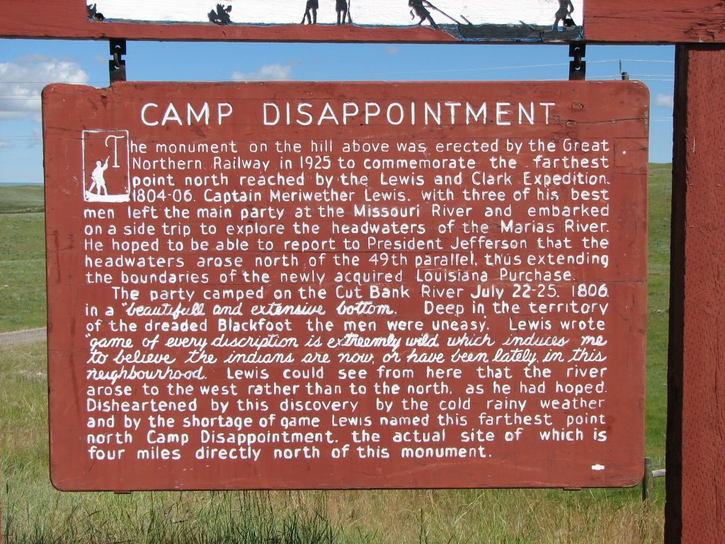
Shelby is on the east side of Glacier National Park (GNP) and is about 50 mile away. On the way there you go through the towns of Cut Bank and Browning. One of the historic points we stopped at was Camp Disappointment. It marks the furthers point north of the Lewis & Clark expedition. Lewis had hoped that the Marias headwaters rose north of the 49th parallel. As that would have extended the boundaries of the Louisiana Purchase.


Montana grows a lot of wheat. In Nebraska, Kansas, etc we saw coal trains that were a mile or so long. They would normally have two engines in front pulling and two engines in back pushing. Here in Montana the trains we have seen are either transporting grain or containers. There are grains elevators along the tracks that fill the cars.


.


The Blackfeet Reservation is a large area east of GNP. This is their ancestral lands. If you are wondering how they got their name, here is a tidbit. “"Blackfoot" is the English translation of the word siksika, which means "black foot." It refers to the dark colored moccasins the people wore, which may have been darkened by dye or by walking through burnt grass after common prairie fires.” Jackie took some pictures as we past through the town of Browning.


We have spent three days in GMP. So our pictures are a compilation and reflect the weather that we experienced here. What a place. The scenery is fantastic, from water falls to mountain peaks. We spent a day on a Red bus tour that went over the Going to the Sun Road from the west to east. We had a lunch stop at the Many Glacier Lodge. This lodge was built by the Great Northern Railroad to entice people to ride their trains and come to the park. During this trip and when we drove back to Logan’s pass in our car, we were lucky to see many animals. Jackie was talking to a resident and he told her that the reason we saw bears was the cold, foggy / misty day. That kind of weather encourages the bears to come out and forage. On sunny days they hole up and wait for evening.


This last picture is of a marmot escaping under a construction barrier. He was scooting around on a narrow part of the road. As I approached he ran in a couple of circles and then made his escape.

If you want a peak of what RVing pitfalls can be like, see: Give it more gas,
http://www.youtube.com/watch?v=uiBfmGYv6bY

Thursday, July 22, 2010

Buffalo & Ten Sleep WY and Reed Point MT

On July 16, we traveled to Buffalo Wy. As we neared Buffalo we stopped to take a few pictures of the Bear Mountains


After we got settled in the campground we took a went into Buffalo to see a little of the town. Clear Creek runs though the town . And, true to it’s name the water is crystal clear. There is a Bicentennial Mall with this sign that we thought had a good message


There several old/historic buildings in the town. Like so many towns in these small western communities that were settled in the late 1800’s there are many original building still standing (and some in the process of falling down).


One of the historic buildings is the Occidental Hotel. It was foundednin1880 and underwent a restoration that was started in 1997 and completed in 2008. National Geographic Traveler took survey of place to stay and the Occidental Hotel was one of the 129 that made the list. There more than 600 hotels nominated.

They many famous people of the old west stay there. They included “Buffalo Bill’, Teddy Roosevelt, Butch Cassidy, the Sundance Kid and members of their gang, and Calamity Jane. There are many picture of these people and headlines of the day on the walls. More picuters are at: http://jackbarbic.shutterfly.com/2208


There are many scenic drives in the area. The next day we decided to take RT 16 to the town of Ten Sleep. Rt.16 is also one of the main routes to Yellowstone. The scenery is fantastic! Ten Sleep is only 65 miles away but with all the stops we made to look and take pictures, the round trip took most of the day. Pictures of the trip to Ten Sleep can  be accessed at: http://jackbarbic.shutterfly.com/2208


Ten Sleep is not a large town and got it’s name from the Indians that populated this region. They would measure distance by the number of times they would sleep over night between destinations. It turns out that Ten Sleep was the half way point as they traversed the Big Horn Basin of Wyoming. We ate lunch in the local saloon / pizza / family dining establishment.


The next day we continued to Reed Point, MT. On the way there we stopped at the Little Bighorn Battlefield. This is one of those places that you could easily spend all day. This battle started on June 25, 1876 and ended the next day. That was only 134 years ago, which really isn’t that far back in history.

“The Little Bighorn Battlefield National Monument memorializes one of the last armed efforts of the Northern Planes Indians to preserve their ancestral way of life” “There were approximately 7000 Lakota, Cheyenne and Arapaho, including 1500-2000 warriors, encamped along the Little Bighorn River “. Their leader was Sitting Bull. The government was forcing all Indians to live on reservations, the Indians were resisting. Not to different from our government is doing to us today.

The problem we had was finding a place to park. We were in the motor home and towing our car. The spots we could fit in near the Visitors Center were all filled so we drove on the road that connects the two battlefields, stopping where we could. Our first stop allowed us to look back on “Last Stand Hill”. This is where Custer and his troops died. It is the site of the Custer National Cemetery. Pictures cannot tell the story of the battle so what we did was to take pictures of the signs that explained what was going on during the battle. I have attempted to put the pictures into a semi-logical order to tell the story. You can accss them at: http://jackbarbic.shutterfly.com/2324  The park map they handout at the gate does an excellent job of telling the story. I have not been able to find it on-line, however, here is a URL that has some of the story. http://www.nps.gov/libi/index.htm


There are memorial markers at the spot or very near to the spot where the soldiers and Indians fell.


There are actually two battlefields that are approximately four and one half miles apart, with many stopping points with interpretive signs describing the many skirmishes that took place during the battle. It was moving to read the signs, look at the pictures of the Indians and soldiers and then look beyond the sign and see the land that it actually took place on.


So, reluctantly we left and we continued on our way.

Reed Point was just a one night stop over . We arrived about late-afternoon and set up. It clouded over and we had some rain. After that I took a walk around “the Town” and took some pictures. As we travel we sometimes wonder what caused a town to be where it is. Well,,,


And, I think they do roll up the sidewalks at night………………..


Wednesday, July 21, 2010

Superior CO, Fort Laramie

July 2, we left Hart Ranch and drove the car to Colorado to visit our son, daughter -in-law and grand kids in Superior CO. A few of the high lights were a trip to the Denver Zoo. Caught the hippo in a big yawn and my grand son, Chris & I shared a seat on the park train.

The afternoon before we left Gabby had a Track & Field event. Chris is too young, next year he will be in kindergarten and can be in it. Gabby ran the 100 meter and came away with a second place ribbon.

               6723


Meanwhile Chris and a friend were having events of their own.


All things must end and the next morning we were on our way back to pick up the motor home and continued our trip. On the way we make a short stop at Fort Laramie. I guess you would call it a power tour. There was a man who was dressed in clothes of the period manning the original bar. He told me that the soldiers made less than $20 a month but a good bar tender would make over $100. He said that the bar tenders were responsible for a lot of the book keeping. Maybe some of it would be called creative bookkeeping.


 Officer, kitchen, bakery, and laundry were on the first floor , while the sleeping quarters were on the second floor.


The fort is near the North Platte River. I never realized how important this river was to the settlement of the west. It was the route for the Oregon and Mormon Trails. It is about 310 miles long, a tributary of the Missouri River and drains a large portion of the central Great Plains in Nebraska and the eastern Rocky Mountains in Colorado and Wyoming. The road we took to the fort crossed the river over a modern bridge. Nearby was the old Fort Laramie Bridge that was built in 1919


The bridge has a lot of bolted joints that I took several pictures of. So, we arrived back at the art Ranch and got the motor home out of the storage lot and on to a site. The next day we went into Rapid City and bought food, etc for the next leg of our journey. We found a great grocery store named Family Thrift. It is like a Publix or Winn Dixie. One of the items that is at the top of my list of favorites is their Dutch Apple Pie. Those stores have a terrific bakery.

I have more pictures at: http://jackbarbic.shutterfly.com/2068